

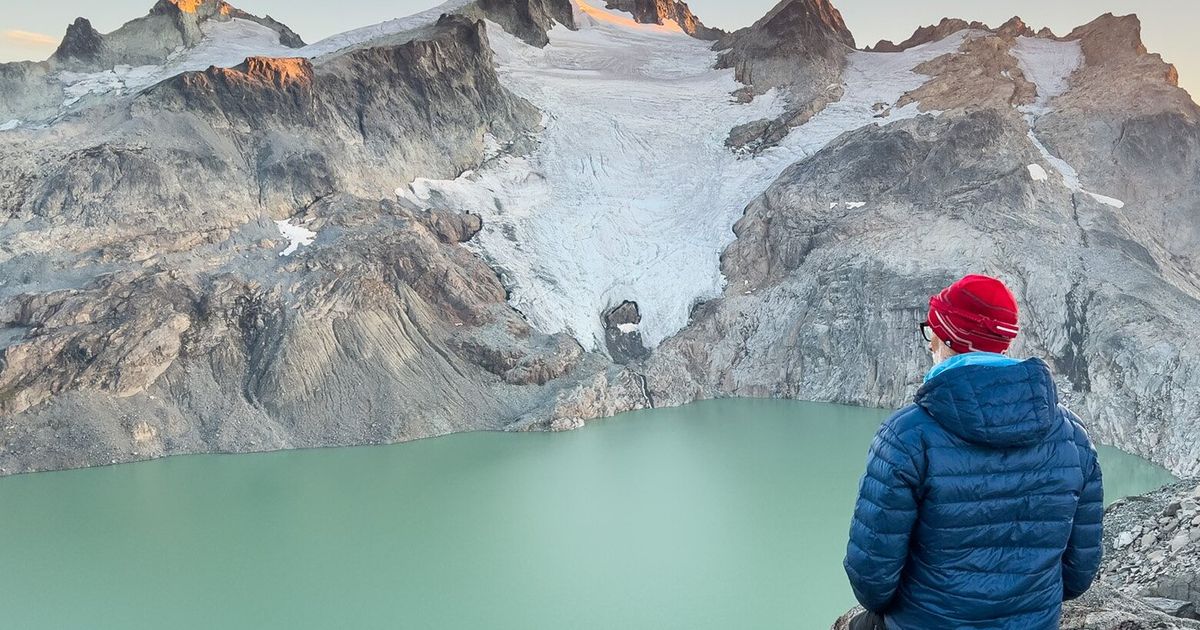
Two old friends and I watched the sunset from Dip Top Gap in Washington’s Alpine Lakes Wilderness. Ridge beyond ridge overlapped into the distance, their jagged outlines growing fainter through wildfire smoke, until the farthest peaks dissolved into the reddish light. We had hiked in to spend an unseasonably warm September night under the stars. Below our rocky camp lay the teal water of Pea Soup Lake. Across it, Lynch Glacier clung to the north side of Mount Daniel.
I had stood on that mountain 20 years earlier. Now, all across the Mount Daniel massif, ice had given way to expanses of raw, newly exposed bedrock.
For a longtime Alaskan, it felt like stepping into a time machine. I was looking at what parts of my own mountain country could become in the coming decades — perhaps sooner.
Washington’s congressional delegation should protect sustained funding for the U.S. Geological Survey’s monitoring of five benchmark glaciers, including South Cascade Glacier in Washington and Wolverine Glacier in Alaska. The Interior Department’s proposed 2027 budget requests no funding for this USGS Ecosystems Mission Area, suggesting that some of its work could instead be carried on by states and universities. Those institutions are essential partners in scientific research, but partnership is not the same as assuming responsibility for a federal record maintained across generations. Once a year of observation is lost, no future grant or appropriation can recover it. What we learn from that ice reaches far beyond the mountains.
Long records like these are easy to take for granted and impossible to re-create once interrupted. Every field season depends on a decision made far from the ice.
Since 2018, I’ve been documenting the lives and work of scientists studying Alaska’s glaciers and the waters they feed. What began as a grant-funded photographic project became an obsession, drawing me back long after the funding ran out. Much of that time has been spent at Wolverine Glacier, above Prince William Sound.
Researchers there maintain a record begun in 1966, measuring one glacier within a vast region of ice and water connected to the sea.
I crossed the crevassed ice with researchers to measure ablation stakes, which are aluminum tubes drilled into the glacier. The more each stake stood exposed above the surface, the more snow and ice the glacier had lost. Alongside snow depth and density, those measurements reveal the glacier’s mass balance: how much it gains and loses.
The majority of the work is hands-on, not without danger, and resolutely analog. Scientists return season after season to dig snow pits, drill firn cores (firn is the stage between snow and glacial ice), measure stakes and maintain meteorological instruments. Back in their offices, they reconcile those observations with weather records and aerial surveys, adding another entry to a decades-long ledger of accumulation and decay.
Why keep measuring glaciers if we already know they are shrinking?
Because “shrinking” describes direction, not pace, timing or consequence. The record tells us how quickly the transition is unfolding, when meltwater is entering streams and the ocean, and what changes as ice becomes a smaller share of the watershed. A missed year can sometimes be estimated; it cannot be observed after the fact. No future appropriation can send scientists back to collect the observations that were missed.
On a subsequent visit, I accompanied USGS researchers sampling streams around Wolverine Glacier. One ran clear through tundra; another emerged from beneath the glacier, opaque with pulverized rock. Downstream, the waters mixed.
The scientists traced the water’s chemical fingerprints — where it came from, what it carried and how it moved through the watershed. They welcomed every question, one of them kneeling to draw the invisible system in pale glacial silt with a stick.
The questions followed the water toward neighboring Prince William Sound. Could the glacier’s mineral-rich runoff help nourish the ocean, and how might changing contributions from ice, snow, rain and groundwater alter what reached the sound, and when?
Later that year, an oceanographer at the Prince William Sound Science Center helped me follow that water into the sea. His work examined the marine waters downstream of the landscapes the USGS scientists studied.
He explained that recent warming has sent an expanding pulse of glacier meltwater into Prince William Sound. Because freshwater is lighter than saltwater, it spreads across the surface, strengthening the separation between surface water and the nutrient-rich depths below. That barrier limits the mixing phytoplankton need to grow. The pulse may intensify before it eventually ebbs as the glaciers lose the ice that feeds it. By then, changes to the food web may be difficult to reverse.
Aboard the research vessel, I watched scientists collect plankton in small bottles and service instruments lowered into the depths. The downstream meaning of my photographs began to emerge.
In Cordova’s harbor, fishing boats crowded the slips. Salmon were the gravity holding the community together, sustaining livelihoods, knowledge and traditions carried across generations. Prince William Sound deserves to be regarded as a national treasure. Understanding its changing waters is a national responsibility.
Washington has its own stake in that knowledge. Glacier-fed streams help sustain summer flows and cool water in the Skagit watershed, where salmon carry profound ecological and cultural importance. National Park Service researchers have used South Cascade’s USGS record alongside other glacier measurements to estimate the Skagit’s summer meltwater supply. The benefits extend beyond the agency collecting the data.
Washington’s glaciers are not an exact forecast for Alaska. But standing above Pea Soup Lake, I felt the distance between the two places narrow. The Cascades offered a glimpse of a future the researchers at Wolverine are already measuring.
The question is not whether these glaciers will continue to retreat. It is whether we will keep measuring what their retreat does to the waters and communities below them. Washington’s delegation should protect the records at South Cascade and Wolverine while they are still continuous. The time to defend a long record is before the gap.
